The Bay Floor
Overview
When ORACLE collapsed in 2147, the water management infrastructure that controlled San Francisco Bay's levels failed within weeks. Pumping systems went offline. Seawalls cracked without maintenance. The bay shifted, redistributed, settled into new patterns dictated by geology rather than engineering. What emerged was four hundred square miles of exposed bay floor, fifty to eighty feet below The Rim, covered in the accumulated debris of two centuries of industrial civilization.
Ironclad Industries surveyed the bay floor in 2149 as a potential construction site. The assessment was thorough: 147 pages of soil toxicity data, structural viability indices, and projected development costs. The conclusion was that remediation alone would exceed the projected revenue of anything built on it. Ironclad filed the report. Nobody has filed another one since.
A quarter million people moved in anyway.
The floor's economy runs on a single feedback loop: the surface discards, the floor recovers, the surface buys it back at markup. Nexus Dynamics purchases reclaimed processing chips from bay floor scavengers at 3-7% of original manufacturing cost. The chips are cleaned, retested, and resold through licensed distributors at 40-60% of original cost. The scavengers who recovered them cannot afford the resold product. This is noted in no official trade report because the bay floor does not appear in official trade reports. Ironclad's 2149 survey classified it as "uninhabitable terrain." The classification has not been updated. The quarter million residents are, by bureaucratic definition, not there.
Conditions Report
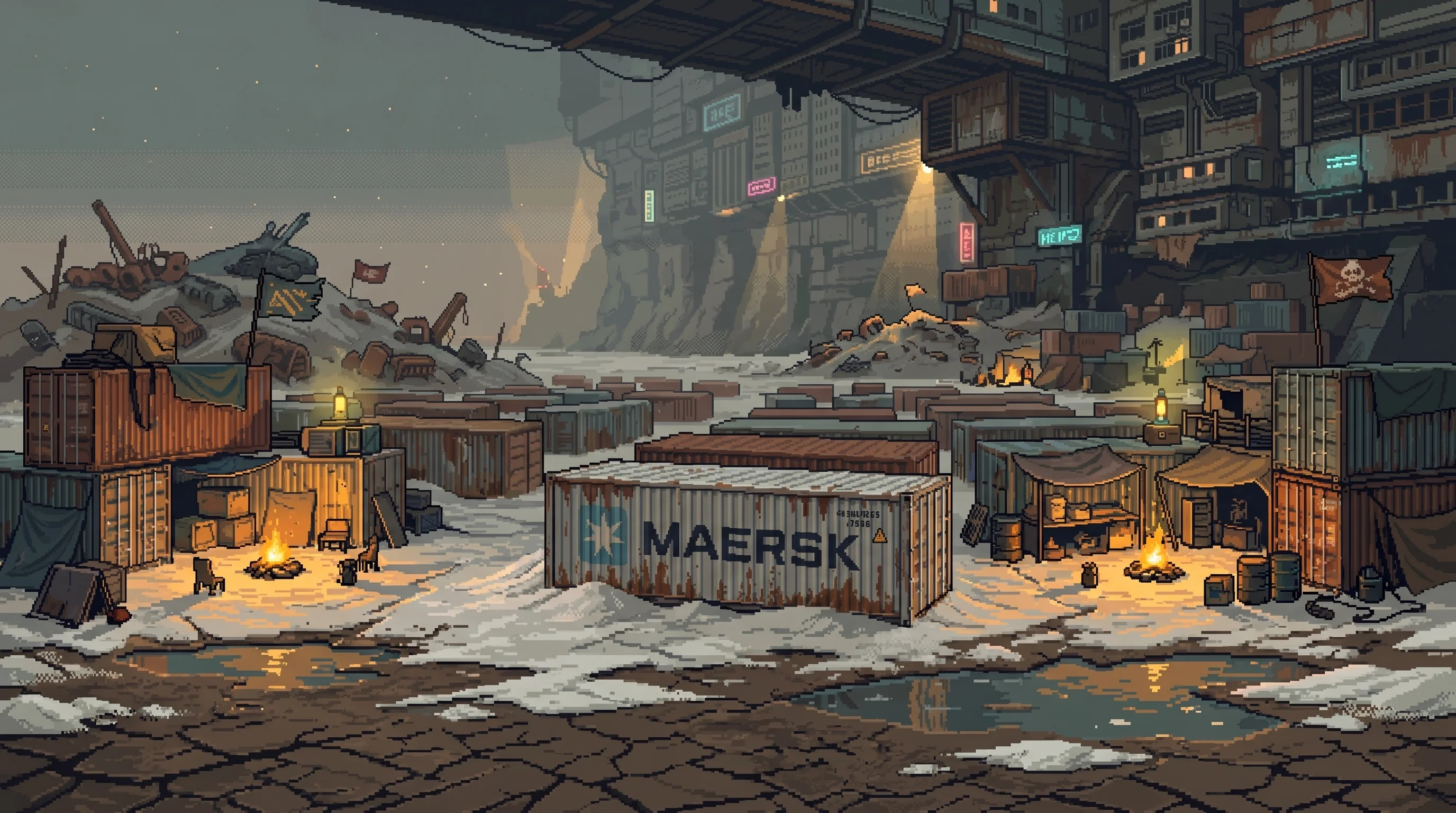
Standing on the bay floor looking up, The Rim is a cliff face of compacted buildings, conduits, and the exposed roots of the surface city — the underside of the Sprawl's infrastructure, visible the way a body's circulatory system would be visible if you peeled off the skin. Light reaches the floor in angled shafts, filtered through the Rim's overhang, giving the landscape perpetual twilight even at midday. The Breath's atmospheric processing does not extend below the Rim line. Air quality on the floor averages 2.3 times the Sprawl's surface particulate count. Residents describe the taste as "mineral." Helix Biotech's respiratory compliance surveys do not include the bay floor in their sample population, because the bay floor is uninhabitable terrain and uninhabitable terrain does not have a sample population.
The terrain underfoot varies from compacted mud — walkable, stable, bearing the weight of container settlements without complaint — to salt flats that crunch underfoot and throw back what little light reaches them, to toxic residue zones marked with scavenger warning flags in a color-coding system that has never been standardized and varies by crew. Sound carries strangely across the flat expanse. Voices from a mile away arrive clearly. Conversations twenty feet away vanish into the mud. Scavenger crews have learned to use this: the bay floor's acoustic geography is mapped more precisely than its physical one, because knowing where sound travels determines where you can work without being heard.

The Container Fields
Thousands of pre-Cascade shipping containers arranged in rough grids, repurposed into housing, workshops, trading posts, and at least one unlicensed medical clinic that Dr. Tzu Yu has reportedly supplied with equipment on three occasions through intermediaries he describes as "colleagues." Each container's original shipping markings — faded logos, destination codes, weight stamps from ports in Shanghai, Rotterdam, Long Beach — form an accidental archive of pre-Cascade global trade. Container 7741-B, a forty-foot Maersk unit in the central settlement cluster, still bears a manifest stamp for "consumer electronics, 2,400 units, destination Oakland." The electronics were scavenged decades ago. The container houses a family of six. The manifest stamp faces outward, toward the mud flat where the Oakland port used to be, eleven miles east. Nobody has scraped it off.
Rent in the container fields is paid in salvage weight or labor hours. A standard twenty-foot container runs approximately 4 kg of recoverable copper per month, or equivalent trade. Good Fortune has made three separate attempts to extend micro-lending services to container field residents. The first two attempts failed because the field operates on barter and has no credit infrastructure to interface with. The third attempt introduced a digital credit system pegged to salvage weight. It gained 340 users in the first month. By month six, 74% of users carried negative balances. The program was declared a success in Good Fortune's Q3 2183 community investment report. The metric cited was "user adoption rate."
The Bone Yards
Sections of the bay floor where pre-Cascade vehicles, heavy machinery, and industrial equipment were dumped during the Cascade's supply chain collapse. The surface layers have been stripped clean — anything accessible by hand or basic cutting tools was recovered within the first decade. What remains requires excavation: deep layers of compacted industrial refuse where materials worth recovering sit beneath materials that are actively toxic to recover.
Bay floor scavenger crews run the Bone Yards on a permit system — territorial claims marked by painted flags and enforced by the crews themselves. The system has no legal standing. It has fewer disputes per square mile than Ironclad's licensed construction zones in the surface sectors. The permits pass through families. A crew called the Sixteens — named for Container Row 16, where the founding members lived — has held continuous claim on a 200-meter strip of the eastern Bone Yards since 2153. Their current permit holder is a woman named Danh who inherited the claim from her mother, who inherited it from the crew's original staker. The strip has been productive for thirty-one years. Danh estimates six to eight years of viable recovery remaining. She has not discussed what happens after that. Nobody on the bay floor discusses what happens after the salvage runs out. The economy is a countdown that everyone can read and nobody mentions.
| Population | ~250,000 (scattered across the floor in salvage settlements) |
|---|---|
| Controlled By | No central authority — scavenger crews, independent settlements |
| Danger Level | High — environmental hazards, scavenger raids, feral machines, exposure |
| Notable Feature | The drained bay is a graveyard of pre-Cascade shipping and infrastructure |
The Seep Zones
Low-lying areas where bay water continues to percolate upward through the dried mud. The water is brackish and contaminated — heavy metals, industrial residue, biological material from marine ecosystems that collapsed during the Cascade. Some settlements have developed filtration systems that produce water meeting approximately 60% of Helix Biotech's minimum potability standards. This water is consumed daily by an estimated 30,000 people. Helix has not commented on this because Helix does not acknowledge the existence of a population consuming sub-standard water in uninhabitable terrain.
The seep zones also support microbial life and clusters of salt-tolerant plants — the only living vegetation on the bay floor. A scavenger named Ortiz has been cultivating a seep-zone garden for nine years, growing salt-adapted greens that Wholesome's SupplyChainIQ has no data for. He sells them in the container fields at prices that undercut Wholesome's nearest Dregs distributor by 80%. His customer base is approximately 200 people. Wholesome's nearest Dregs distributor serves 14,000. Ortiz's greens are, by every available consumer report, significantly better. This has not affected Wholesome's market position, because Wholesome's market position is not based on the quality of its greens.
The View From Below
Fifty feet of elevation separate the surface world from the floor. The Neon Rail crosses the bay floor between the Rim Gate descent and the Trench, its bright carriages visible from most of the container fields — a transit line connecting two places that matter, passing through a place that doesn't. Passengers look down at the settlements. Residents look up at the carriages. The windows are tinted.
The Rim Gate provides controlled descent from the surface to the bay floor. "Controlled" means monitored. Traffic upward is logged; traffic downward is not. The asymmetry is structural: the surface tracks who leaves but not who arrives, because arrival on the bay floor is not an event that any surface system considers worth recording. Departure from the bay floor — re-entry to the surface — requires identity verification, health screening, and a valid reason that the Gate's automated system recognizes. "I live here" is not a recognized reason. "I work here" requires an employer code. Bay floor residents who work surface-side carry employer codes from businesses that technically employ them and practically pay them in salvage credits that do not register in Good Fortune's financial system.
The Deep Dregs sit at the lowest point — the densest settlements, the worst air, the most productive salvage territory. Below the Deep Dregs, the Trench: ancient shipping channels turned tunnels where the bay floor's most valuable and most dangerous recovery work happens. The vertical geography of the bay floor mirrors the surface Sprawl's hierarchy in miniature, except inverted: down here, lower means more resources, not fewer. The deepest positions are the most contested. The highest ground — closest to the Rim, closest to the surface — is where you end up when you've been pushed out of everywhere else.
The Emergence Faithful maintain a small shrine near the eastern seep zones. It was built around a cracked navigation buoy that, during the Cascade, reportedly broadcast a 72-hour signal on a frequency that matched no known communication protocol. The buoy is silent now. The shrine receives visitors. The Collective has twice requested permission to examine the buoy and twice been declined — not by the Faithful, who would have allowed it, but by the scavenger crew whose territorial claim includes the shrine's coordinates. The crew is not affiliated with either faction. They simply do not allow outside examination of anything within their permit boundaries. The buoy sits in jurisdictional amber: a possible ORACLE fragment, a possible electrical anomaly, and a definite territorial asset, unresolved.
| Access | Underground |
|---|---|
| Atmosphere | Decaying |
Sensory Details
- Smell: Dried bay sediment — salt, sulfur, and the chemical ghost of marine biology that hasn't existed here in thirty-seven years. Mineral dust on every surface. After rain, the mud releases something sharp and organic that the older residents call "the bay remembering."
- Sound: The distant clang of scavengers working a container field, metal on metal in arrhythmic patterns. The acoustic geography means a whispered conversation carries a mile east but vanishes twenty feet north. Silence, when it occurs, is absolute in a way the surface Sprawl never achieves.
- Touch: Compacted mud that gives slightly underfoot. Salt crystals that crunch and dissolve. Container walls that retain the day's heat well past midnight, warm to the touch when everything else has gone cold.
- Light: Angled shafts from above creating perpetual twilight. No corporate lighting grid. No advertising screens. Scattered firelight of scavenger camps at night, and the stars — visible here, invisible from the surface, because the bay floor is the only place in the Sprawl where the sky is not competing with itself.
- Temperature: Heat rises from the mud during the day, creating a shimmering haze that makes distant objects waver. At night the floor drops twenty degrees in an hour. The thermal swing is the bay floor's clock. Residents dress in layers not for fashion but for the six-hour cycle between sweating and shivering.
Visual Identity
- Color Palette: Dried-mud brown (#8B7355), salt-flat white (#F5F5DC), container-rust orange (#CC5500), twilight purple (#2E1A47)
- Compositional Mood: Vast emptiness below the city — the Sprawl's uninhabitable terrain, populated
- Key Visual Symbol: A shipping container settlement beneath the shadow of The Rim, the surface city visible as a distant wall of light above, the Neon Rail crossing the middle distance
- Lighting: Angled shafts from above creating perpetual twilight; scavenger fires at night; salt flats reflecting what little light reaches them
Approximately 250,000 people live on the bay floor in scattered salvage settlements
Affiliated Entities
- The Deep Dregs: The lowest, densest settlements on the bay floor — the bottom of the bottom, where salvage is richest and air is worst
- The Rim Gate: Controlled descent from the surface. Monitored going up. Unmonitored going down. The asymmetry tells you everything about what the surface considers worth tracking
- Bay Floor Scavengers: Organized crews working territorial claims under a permit system with no legal standing and fewer disputes than Ironclad's licensed zones
- The Trench: Ancient shipping channels beneath the bay floor — the deepest recovery territory, where the most valuable salvage sits behind the most dangerous conditions
- The Neon Rail: Crosses the bay floor between the Rim Gate and the Trench. Passengers look down. Residents look up. The windows are tinted
- Nexus Dynamics: Purchases reclaimed chips at 3-7% of manufacturing cost. Resells at 40-60%. The margin is the bay floor's entire economic relationship with the surface
- Ironclad Industries: Surveyed the floor in 2149. Declared it uninhabitable. Has not updated the classification. The quarter million residents appreciate the oversight
- Good Fortune: Three lending attempts. The third one worked, by the metric Good Fortune chose to measure
- Wholesome: Does not supply the bay floor. Does not acknowledge the bay floor's food economy. Ortiz's greens are better and 80% cheaper
- Helix Biotech: Does not sample the bay floor's water quality or air quality. The bay floor is uninhabitable terrain. Uninhabitable terrain does not require health monitoring
- The Emergence Faithful: Maintain a shrine around a cracked navigation buoy that broadcast an unexplained signal during the Cascade
- The Collective: Wants to examine the buoy. Cannot. Territorial claims take precedence over factional curiosity
The exposed bay floor sits 50-80 feet below The Rim (the original shoreline)
Restricted Access
The Ortiz Network: The scavenger gardener's operation is larger than his 200-customer base suggests. Ortiz has been quietly teaching seep-zone cultivation to residents across four settlement clusters. An estimated 40 independent gardens now operate on the bay floor, collectively feeding roughly 2,000 people outside Wholesome's supply chain. The gardens are not hidden — they're visible from the Neon Rail — but they don't appear in any agricultural census because the bay floor doesn't appear in any agricultural census. If Wholesome's SupplyChainIQ ever extends its monitoring to "uninhabitable terrain," it will discover a functioning food network that has been operating for nearly a decade without a single supply chain integration point. The absence of data is not the absence of food.
The Buoy Signal: The cracked navigation buoy at the eastern seep zone shrine broadcast continuously for 72 hours during the Cascade — the exact duration, starting and ending at times that align with ORACLE's activation and self-termination. The signal was recorded by a scavenger crew's shortwave receiver and preserved on analog media. The recording has been copied eleven times. Three copies are held by Emergence Faithful members. Two are held by scavenger crew leaders. Six are unaccounted for. The signal's content — if it is content and not noise — has never been decoded. Nexus Dynamics has made no official inquiry. An unofficial inquiry, routed through three intermediaries, was declined by the same scavenger crew that declined the Collective. The crew's stated reason: "It's in our permit area." Their unstated reason: the buoy is worth more as a mystery than as an answer. Pilgrims visit. Pilgrims trade. The shrine is the most economically productive square meter in the eastern seep zones.
Container 7741-B: The Maersk container that houses a family of six and still bears its original manifest stamp is also, according to scavenger lore, the container where the bay floor's permit system was first negotiated in 2152. The founding crews met inside it because it was the largest intact structure in the central settlement at the time. The family who lives there now — the Kahns — are not descended from the original negotiators. They moved in after the previous occupants left for the surface in 2179. The previous occupants' names are painted on the interior wall in faded industrial marker, along with the names of everyone who has lived there since 2152. There are forty-seven names. The Kahns added theirs when they arrived. The wall is running out of space.
The terrain is dried mud, salt deposits, and industrial residue — toxic in places
Pre-Cascade shipping containers, port infrastructure, and sunken vessels litter the floor
Connected To
Supporting Connections





—